
1
- Place
- Airport
- Latitude °N
- 69.6819
- Longitude °E
- 18.9138
Days in Tromsø

The short answer
Use the numbered map for broad orientation, then the operator’s address and current transport for the actual journey. The points are sourced place locations, not entrances or routes. Airport, town and mainland pickups need separate checks.
Last updated October 2026
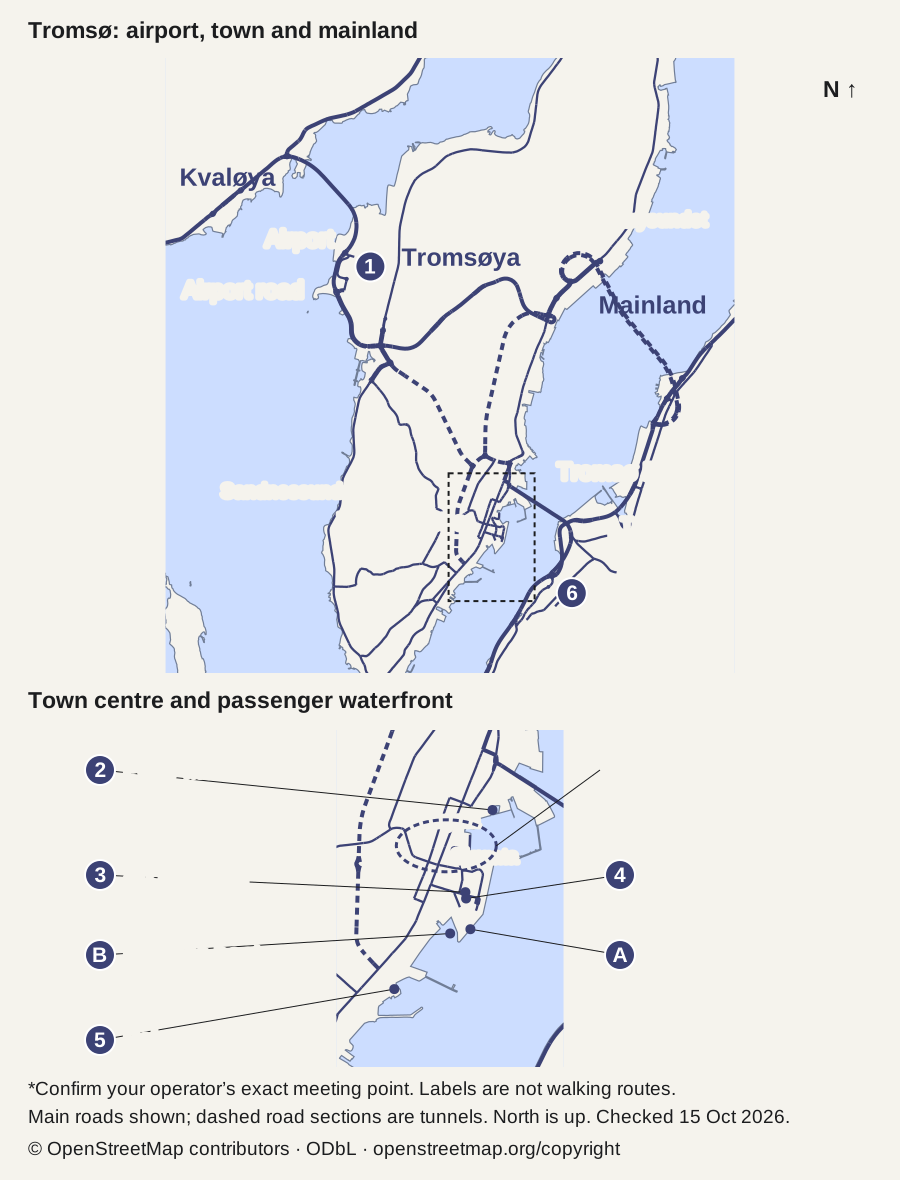
The airport and town centre are on Tromsøya. The cable-car lower station is across the sound on the mainland. The town-centre enlargement separates the museums, passenger waterfront and central pickup area. Tap the map to enlarge it.
| Key | Place | Latitude °N | Longitude °E |
|---|---|---|---|
| 1 | Airport | 69.6819 | 18.9138 |
| 2 | Polar Museum | 69.6522 | 18.9633 |
| 3 | Art museum | 69.6483 | 18.9596 |
| 4 | Prostneset area | 69.6480 | 18.9597 |
| 5 | Polaria | 69.6437 | 18.9499 |
| 6 | Cable-car lower station | 69.6410 | 18.9864 |
Complete place key
OpenStreetMap contributors: point data and rights · Checked . © OpenStreetMap contributors, ODbL 1.0. Coastline and main roads, simplified for orientation. openstreetmap.org/copyright.
This Tromsø map separates arrival, central town and the mainland cable-car area. Use it to know where the main places lie before searching transport. The island outline and main roads show how the airport, town and cable-car station relate. The waterfront enlargement helps with central arrivals. Use current instructions for your exact berth or pickup.
Use the numbered map for broad orientation, then the operator’s address and current transport for the actual journey. The points are sourced place locations, not entrances or routes. Airport, town and mainland pickups need separate checks.
For the journey, use the operator's address and the dated planner. A dot on an airport area is not its arrivals door. A neighbourhood point is not a terminal entrance.
The map and coordinate records appear above this guide.
The coast separates Tromsøya from Kvaløya to the west and the mainland to the east. Main roads come from OpenStreetMap. The Tromsø Bridge crosses the sound towards Tromsdalen; the cable-car lower station is on that mainland side. Short thin lines connect numbered dots to labels. They are not walking routes.
The north-up map keeps east-west distance in proportion at the local scale. The centre is enlarged below the wider view so the waterfront places remain distinct. Open the full-size image to read the smaller streets on a phone. Use a current transport source for the actual journey.
| Key | Place | Latitude °N | Longitude °E | Source point |
|---|---|---|---|---|
| 1 | Airport | 69.6819 | 18.9138 | OSM record |
| 2 | Polar Museum | 69.6522 | 18.9633 | OSM record |
| 3 | Art museum | 69.6483 | 18.9596 | OSM record |
| 4 | Prostneset area | 69.6480 | 18.9597 | OSM record |
| 5 | Polaria | 69.6437 | 18.9499 | OSM record |
| 6 | Cable-car lower station | 69.6410 | 18.9864 | OSM record |
Scroll for more →
The point records were retrieved on 14 October 2026. Coastline and main-road geometry were retrieved on 15 October 2026. Coordinates are rounded to four decimal places. They describe the mapped place, not a surveyed access or pickup position.
OpenStreetMap contributors supply the coordinates under ODbL 1.0. The small source-point dataset is available as Tromsø place data. Each record above links to its source feature. The coastline and road extract is also available under ODbL 1.0. The map simplifies the geometry for legibility; it does not include every local road or footpath.
The airport value is an aerodrome-area point. Prostneset is a neighbourhood point. The cable-car marker identifies the lower station.
The airport point lies north-west of the central town points on the plot. Avinor supplies current airport details. Use our arrival guide for the last transfer rather than treating the dot as a route.
The museum is north of the other central markers here. UiT's visit record gives its official visitor context. Check the date and route before a visit; the plot does not establish opening.
The Nordnorsk Kunstmuseum point is in the central group. The Tromsø venue page gives the Sjøgata address. Use that branch's record rather than another museum location in Norway.
The enlarged map labels the central passenger waterfront around Prostneset. Havila's terminal list names Samuel Arnesens gate 5 for Tromsø, checked October 2026. The coastal quay and the express-boat side are distinct stops within this area. Match the ship and operator to the exact quay, then use the cruise-port guide for arrival planning.
The marked central pickup area is a broad area only. Confirm the actual tour meeting point with your operator.
Polaria's marker lies south-west of the central museum group. The venue's ticket record supplies the dated visit and inclusion details. It is separate from the nearby bus-stop record with the same name.
The lower-station point is east and south of the central group. Fjellheisen's page gives its current visitor and construction notices. Read the cable-car guide before planning the transfer.
The map shows the airport road and the bridge towards Tromsdalen. Dashed road sections mark tunnels; they are not pedestrian routes. Use Svipper for current buses and stops. Check the date and time, since road geometry does not establish a running service or a suitable winter walk.
For walking, choose a lawful route suited to the current surface and every traveller's needs. The straight label lines should never be followed as paths. Snow or ice can change the effort without changing a point's coordinates.
The cable-car access notice also needs its own check. A station point shows location, not present wheelchair access or parking. The current construction notice must be read before that journey.
For a ship visit, use the exact berth and return deadline. Breivika is not shown as a universal town pickup here. A ship labelled Tromsø can arrive away from the central passenger area.
The map and place table remain visible when printing this page. Use the browser's Print command, with the map and key together. The SVG contains its own attribution for a standalone copy.
For printed credit, retain: © OpenStreetMap contributors, https://www.openstreetmap.org/copyright. Keep the checked date and note that dots are place points. A printout is static and cannot carry a live transport update.
This is a dated static reference. Recheck transport and access for the actual journey.
The Tromsø activity selector helps choose the content of a day. Hotel-area planning helps fit the sleeping base to pickups. Use the map after those choices to compare broad location, then settle the transfer.
For an aurora evening, compare local tour formats from their meeting points and returns. This point map does not nominate a dark-sky viewing spot or a winter mountain path.
No. They join numbers to dots only. Use a route and the current access details.
They find source places. The operator's exact meeting instructions settle where to wait.
Use it for broad orientation, then check transport and access again. The printed date matters.
Place points checked: 14 October 2026. Coastline, roads and the terminal address checked: 15 October 2026.
Use the Tromsø map to separate the broad locations, with the source key beside it. For travel, follow the actual operator address, current route and access notice. A correct place point helps orientation without claiming to be an entrance, safe path or live timetable.